Trail:
Štrbské Pleso (1 350 m.a.s.l.) – Popradské pleso (1 500 m.a.s.l.) – rázcestie nad Žabím potokom – Vyšné Kôprovské sedlo (2180 m.a.s.l.) – Kôprovský štít (2363 m.a.s.l.)
The same trail done on the way back.
Elevation gain: 1 013 m m.a.s.l.
Duration: all-day – 6:20 h ( ↑ 3:25 ↓ 2:55)
Fitness level of difficulty: 2/3
Technical level of difficulty: 1/3
Starting point:
• Štrbské Pleso
• TEŽ stop Popradské Pleso
Chalets along the trail:
• Chalet by the Poprad tarn (Chata pri Popradskom plese)
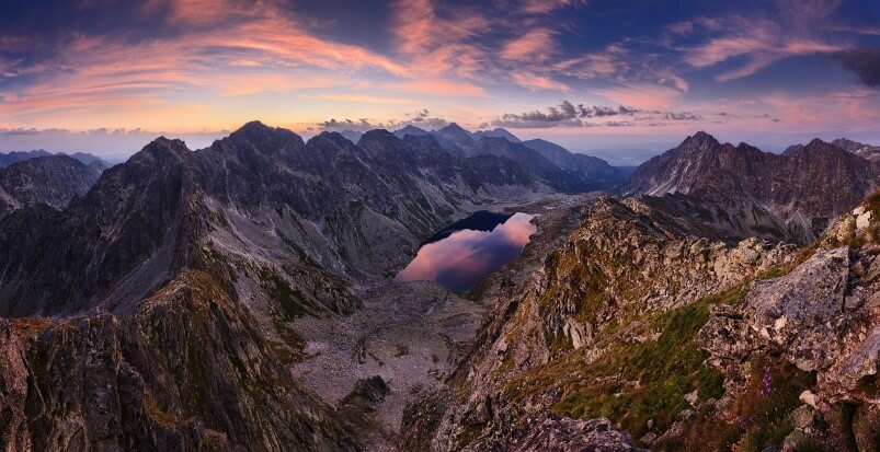
From Štrbské Pleso along the Tatranská magistrála (Tatra Highway) via Trigant, or taking a paved road from TEŽ stop – Popradské pleso, you will reach junction near Chata pri Popradskom plese in about an hour. From there, it will take 30 min’s walk in the forest, later in the dwarf-pine zone until getting to the junction above Žabí potok. Here, the red-marked trail bends northward across the Kotlina Žabích plies (Basin of Frog tarns) to Chata pod Rysmi. The ascent follows the waymarked trail to the northwest, along the Hincov potok (brook) up to the Hincová kotlina (basin). The trail passes between two tarns of Malé Hincovo pleso (1,921 m.a.s.l.) and Veľké Hincovo pleso (1,946 m.a.s.l.), which is the largest and deepest tarn in the Slovak territory of the High Tatras. The path than meanders along the steep slopes of Vyšné Kôprovské sedlo (2,180 m.a.s.l.), from where it begins to descend through Hlinská and Kôprová valleys to Tri studničky. From the saddle it is possible to pick a northwest route taking you right to the top of Kôprovský štít (2,363 m.a.s.l.) On the way back we take the same route or descend through Hlinská and Kôprová valleys to Tri studničky, although it takes much longer ( 5:45 h).
Views from the top:
The summit has beautiful views over the valleys and offers a panorama with Hrubô (2,172 m.a.s.l.), Čubrin (2,378 m.a.s.l.), Mengusovský štít, Rysy (2,499 m.a.s.l.), Mengusovský Volovec (2,227.5 m m.a.s.l.) and Vysoká (2 547 m.a.s.l.).
")
 (1500 m.a.s.l.)")
 1295 m.a.s.l.")